Manufacturing Plant Expansion Drone Documentation in India
How factories can document expansion, new buildings, yards, utilities and stakeholder progress while protecting sensitive operations.
By SkyViews Aerial Drone Studio
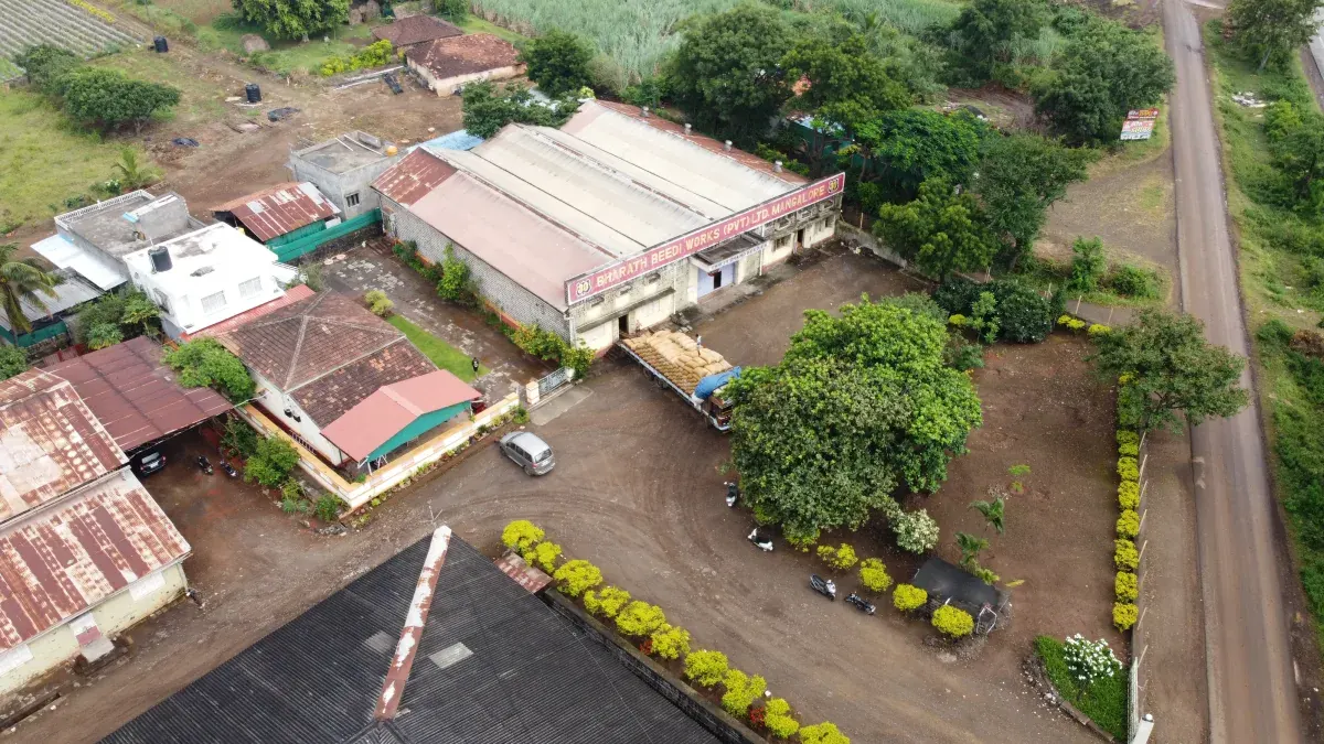
A factory expansion often happens beside a working plant. New foundations, a building shell, access roads and utility corridors may be visible from above while production continues nearby. Aerial images can help owners and project teams explain how these parts fit together. They are most useful when every capture answers a defined question and respects the site's safety and confidentiality needs.
This guide is for manufacturing owners, project managers and communications teams in India. It explains how to plan an aerial record from early works through handover, how to compare visits, and how to prepare different outputs for internal and public use. Images show visible conditions on a date. They do not certify construction quality, equipment performance or readiness to operate.
Decide what the record is for
An expansion may include a production building, warehouse, yard, internal road, gate, drainage route, utilities and landscaping. List the components that matter to the decision maker. The project director may need a monthly view of access and sequencing. A lender may want dated milestone context. The engineering team may need a visual record before an area is covered by later work. Marketing may want a clear view of the completed campus.
These needs cannot always be met by the same film. A short public video can show scale and progress without revealing process details. An internal report may need labels, dates and close views of external work. A technical record may require an exact location and repeat angle. Write the audience and intended use beside each requested output before creating the shot list.
Choose a reporting boundary. Mark the existing plant, expansion zone, contractor area, roads and neighbouring property. Include a simple site plan with consistent names for each block and yard. A caption such as “north warehouse roof installed” is understandable only if every reader knows which building the team calls north warehouse.
Prepare the operating site with the facility team
The facility owner should appoint a contact who can coordinate production, security, safety and the construction contractor. Review site induction, vehicle routes, loading times, crane activity, overhead lines, tall stacks, exhaust, restricted areas and safe take-off options. A flight around a live plant requires a site-specific plan by the qualified operator. Do not assume that a clear sky means the airspace and site conditions are suitable.
Draw no-film zones on the plan. These may cover proprietary production lines, supplier material, customer goods, security systems, control rooms or adjacent property. A wide shot can still reveal details in the background, so the review must include the whole frame, not just the main subject. If a confidential process is visible through a roof opening or yard, change the angle or wait for an approved window.
Discuss people and traffic early. Workers, visitors and drivers may move through the planned view during a shift. A quieter slot can improve both safety and clarity, but stopping operations is a business decision for the facility. The crew should know who can pause work or authorize access, and the facility should know that the pilot retains control of the flight decision.
Record the starting condition
An expansion record is stronger when it starts before major work hides the original ground. Capture the existing access, boundary, nearby structures and visible site condition where approved. Save a dated site plan and the first set of reference photographs. If the team later asks how a yard, road or boundary changed, these baseline views provide context.
Keep normal photographs from ground level too. Aerial images explain the layout but may not show a material tag, crack, service connection or installation detail. Pair each milestone with the records that actually prove it: contractor reports, survey data, inspection forms, test documents and signed approvals. The aerial set should help people find and understand those records.
Use repeat viewpoints for progress
Choose a small set of views that can be captured on every visit. One high context view may show the expansion beside the existing plant; a second can show building progress; another can show yard and access changes. Record the approximate position, height, direction, camera setting and any restrictions. Give each view a stable ID, such as View 01: east gate toward new warehouse.
Repeat the same boundary, view IDs and building names in every report. Put the date on the image or caption. Keep weather and visibility notes because haze, rain or shadow may hide work that is present. If a crane, temporary shelter or access restriction forces a different angle, record the change. A side-by-side comparison should disclose that the views differ rather than silently suggesting direct measurement.
Agree a cadence tied to the project schedule. Monthly capture may suit a long construction period. Shorter intervals can help around foundations, roof installation or access changes. If a planned visit is skipped because of weather or operations, leave a gap in the record and note why. Do not backfill a missing milestone with an undated or unrelated image.
Make the report easy to use
A practical progress package begins with the capture date, project stage, site map and a short note on what could be filmed. Then show the repeat views in a predictable order. Under each image, write a plain observation, such as “roof sheets visible on the west block” or “temporary storage occupies the south yard.” Avoid claims about percentage complete unless those figures come from the project controls team and are clearly attributed.
Use annotations carefully. A circle or arrow can direct a reader to a change, but it should not cover the original detail. Keep a clean original next to the annotated copy. If the client asks for a map, panorama or model, define the accuracy and processing method separately. A stitched image made for presentation is not a survey drawing.
The report can include an exceptions page: weather affected visibility; the north side was closed; the planned west view could not be captured; or a temporary crane changed the composition. These notes make later review more honest and save time when someone asks why a feature is absent.
Separate visible progress from technical completion
An aerial view may show a finished roof, laid pavement or installed external equipment. It cannot confirm weld quality, electrical testing, fire systems, machinery commissioning or the legal status of an occupancy approval. Use wording such as “appears installed from the aerial view” when that is what the image supports. If the project needs a completion statement, the responsible engineer or authority must provide it from the proper records.
Similarly, a clean yard in a photograph does not prove that logistics are ready for full production. The site may still need traffic trials, training, signs, drainage checks and operating procedures. Treat the drone record as one layer in the handover file, with links to the relevant technical evidence.
Protect restricted information in every version
Agree who may see raw files, who reviews edits, and which version is approved for public release. An internal image might show a customer order, prototype, security gate or production capacity detail that cannot appear in a corporate film. Public edits should be reviewed by the facility's security and communications owners before distribution.
Use filenames that contain the date, asset, view ID and version. Keep source media apart from approved images so a draft cannot be mistaken for a released file. State whether the client receives raw footage, how long it will be retained, and who can reuse it for later reports. A future team should be able to trace a public image to the capture date without gaining access to everything filmed that day.
Plan the final handover
Near the end of construction, repeat the baseline overview where possible and add approved views of completed external areas. Pair them with earlier dates in a short sequence. Include a location plan and a list of what the aerial set does and does not show. The final package might contain labelled stills for the asset record, a short executive video and a separate set for marketing after review.
The clearest story follows the site's real sequence: original layout, early works, structure, roof and envelope, access and yard, then the final external condition. It avoids suggesting that a visually complete building is fully operational. For broader reporting methods, see the construction KPI guide and commercial pre-flight checklist.
FAQs
Can a factory be filmed while production continues?
It may be possible with facility approval, a safe operating plan, security review and coordination with the construction and production teams. The exact flight depends on current airspace, weather, site activity and the qualified operator's assessment.
Can aerial imagery prove a plant is ready to operate?
No. It can document visible external construction and site context. Commissioning, safety checks and operational readiness need technical records and responsible sign-off.
Can expansion progress be captured monthly?
Yes. Set the viewpoints, boundary, labels and delivery format at the start. Record each date and any difference in access or conditions so the sequence remains useful.
Plan your project
Share your site, dates and intended output so we can confirm a suitable scope.
Explore drone services · Compare project scope · Get in touch
Related reading
- Commercial Facility Handover Drone Documentation in India
- Commercial Drone Data Security in India: Client Planning Guide
- Commercial Drone Shoot Call Sheet: What to Include Before Crew Arrival
- Real-Estate Investor Data-Room Drone Visuals: Documentation Guide
- Property Broker Drone Photography in Bangalore: Listing Guide
- Drone Service RFP Scope Template for India Projects
Contact SkyViews Aerial Drone Studio at +91 90190 56479 or skyviewsdronestudio@gmail.com. Service area: Bangalore, Karnataka and India and wider Bangalore, Karnataka and India.